File:Landing on Queen Red Beach, Sword Area.jpg
Jump to navigation
Jump to search

Size of this preview: 611 × 600 pixels. Other resolutions: 244 × 240 pixels | 489 × 480 pixels | 782 × 768 pixels | 1,043 × 1,024 pixels | 1,805 × 1,772 pixels.
Original file (1,805 × 1,772 pixels, file size: 638 KB, MIME type: image/jpeg)
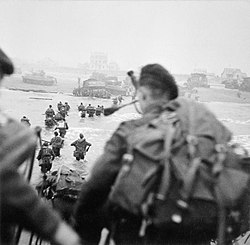
| Description | IWM caption : OPERATION OVERLORD (THE NORMANDY LANDINGS): D-DAY 6 JUNE 1944. The British 2nd Army: Commandos of 1st Special Service Brigade landing from an LCI(S) (Landing Craft Infantry Small) on 'Queen Red' Beach, SWORD Area, at la Breche, at approximately 8.40 am, 6 June. The brigade commander, Brigadier the Lord Lovat DSO MC, can be seen striding through the water to the right of the column of men. The figure nearest the camera is the brigade's bagpiper, Piper Bill Millin. | |||
| Date | ||||
| Source |
|
|||
| Author | Evans, J L (Capt), No 5 Army Film & Photographic Unit | |||
| Permission (Reusing this file) |
|


| Camera location | | View this and other nearby images on: OpenStreetMap |
|---|
| Annotations | This image is annotated: View the annotations at Commons |
- ↑ http://lion-hermanville-cpa14.net/index7.php?menu=juin6_menuG&page=guerreJuin6
- ↑ http://lion-hermanville-cpa14.net/index7.php?menu=juin6_menuG&page=guerreJuin6
- ↑ http://lion-hermanville-cpa14.net/index7.php?menu=juin6_menuG&page=guerreJuin6
File history
Click on a date/time to view the file as it appeared at that time.
| Date/Time | Thumbnail | Dimensions | User | Comment | |
|---|---|---|---|---|---|
| current | 10:19, 1 February 2025 | | 1,805 × 1,772 (638 KB) | wikimediacommons>Ich | larger |
File usage
The following page uses this file:
