File:Prohibited Area P-40 Camp David.png
Jump to navigation
Jump to search
Size of this preview: 800 × 574 pixels. Other resolutions: 320 × 230 pixels | 640 × 459 pixels | 1,002 × 719 pixels.
Original file (1,002 × 719 pixels, file size: 408 KB, MIME type: image/png)
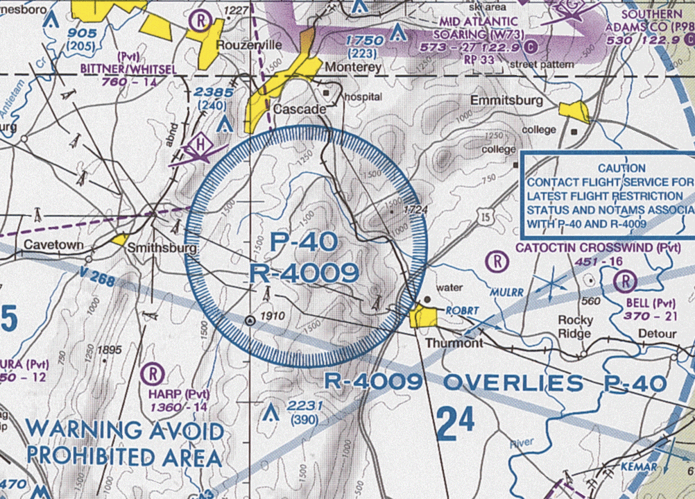
| Description |
English: Section of VFR Terminal Area Raster Aeronautical Chart Baltimore/Washington, 84th edition, showing the prohibited area P-40 and restricted area R-4009 around Camp David Note: This map is valid until 26 July 2012. For navigational purposes, be sure to get the newest edition at the official FAA website |
| Date |
|
| Source | Baltimore-Washington_TAC_84.tif in Baltimore-Washington_TAC_84.zip. Note: The ZIP-File may become unavailable when the map is updated, newer editions will be available here |
| Author | US Department of Transportation, Federal Aviation Administration, National Aeronautical Navigation Services |
| Other versions |
This image or file is a work of a Federal Aviation Administration employee, taken or made as part of that person's official duties. As a work of the U.S. federal government, the image is in the public domain in the United States.
|
 |
File history
Click on a date/time to view the file as it appeared at that time.
| Date/Time | Thumbnail | Dimensions | User | Comment | |
|---|---|---|---|---|---|
| current | 08:34, 24 May 2012 | | 1,002 × 719 (408 KB) | wikimediacommons>El Grafo | update |
File usage
The following 2 pages use this file:
