File:Tide legal use.gif
Jump to navigation
Jump to search
No higher resolution available.
Tide_legal_use.gif (720 × 477 pixels, file size: 31 KB, MIME type: image/gif)
Summary
| Description |
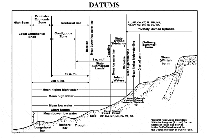
English: The principal tidal data related to a beach profile. The intersection of the tidal datum with land determines the landward edge of a marine boundary. |
| Source |
From NOS Tidal Datums Pub (on Naval Postgraduate School). http://www.oc.nps.navy.mil/nom/day1/partc.html figure:a http://www.oc.nps.navy.mil/nom/day1/tidal_datums_fig17.gif |
| Author |
Licensing
This file is a work of a sailor or employee of the U.S. Navy, taken or made as part of that person's official duties. As a work of the U.S. federal government, it is in the public domain in the United States.
|
 | |
| This file has been identified as being free of known restrictions under copyright law, including all related and neighboring rights. | ||
Original upload log
Transferred from en.wikipedia to Commons using For the Common Good.
The original description page was here. All following user names refer to en.wikipedia.
| Date/Time | Dimensions | User | Comment |
|---|---|---|---|
| 00:41, 12 April 2007 | 720 × 477 (31,829 bytes) | w:en:Rmo13 (talk | contribs) | page: The principal tidal datums related to a beach profile. The intersection of the tidal datum with land determines the landward edge of a marine boundary. From NOS Tidal Datums Pub (on Naval Postgraduate School). http://www.oc.nps.navy.mil/nom/day1/par |
File history
Click on a date/time to view the file as it appeared at that time.
| Date/Time | Thumbnail | Dimensions | User | Comment | |
|---|---|---|---|---|---|
| current | 09:16, 20 November 2016 | | 720 × 477 (31 KB) | wikimediacommons>Mcapdevila | Transferred from en.wikipedia: see original upload log above |
File usage
The following page uses this file:
