File:Corrientes-oceanicas.png
Jump to navigation
Jump to search
Size of this preview: 800 × 418 pixels. Other resolutions: 320 × 167 pixels | 640 × 334 pixels | 1,000 × 522 pixels.
Original file (1,000 × 522 pixels, file size: 75 KB, MIME type: image/png)

|
File:Corrientes-oceanicas-en.svg is a vector version of this file. It should be used in place of this PNG file when not inferior.
File:Corrientes-oceanicas.png → File:Corrientes-oceanicas-en.svg
For more information, see Help:SVG. |
 |
Summary
| Description |
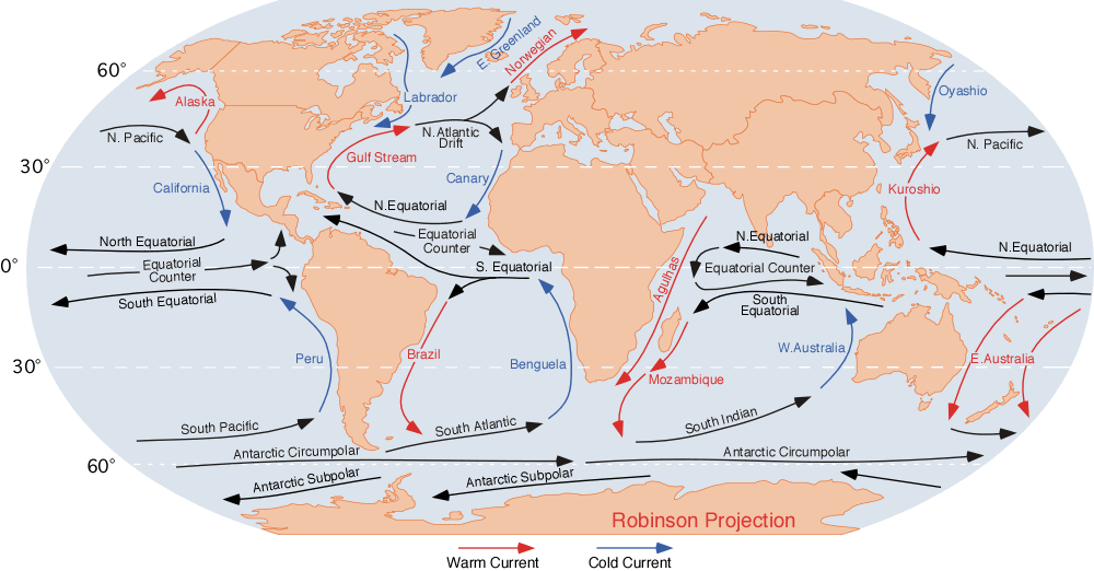
English: the ocean currents.
Note that
Finally, a few gyres also exist at the poles (not shown at this map); these are:
|
| Date | |
| Source | http://blue.utb.edu/paullgj/geog3333/lectures/physgeog.html, original image |
| Author | Dr. Michael Pidwirny (see http://www.physicalgeography.net) |
| Permission (Reusing this file) |
Public domain. U.S. government publication. |
Licensing
This work is in the public domain in the United States because it is a work prepared by an officer or employee of the United States Federal Government as part of that person’s official duties under the terms of Title 17, Chapter 1, Section 105 of the US Code.
Note: This only applies to original works of the Federal Government and not to the work of any individual U.S. state, territory, commonwealth, county, municipality, or any other subdivision. This template also does not apply to postage stamp designs published by the United States Postal Service since 1978. (See § 313.6(C)(1) of Compendium of U.S. Copyright Office Practices). It also does not apply to certain US coins; see The US Mint Terms of Use.
|
 | |
| This file has been identified as being free of known restrictions under copyright law, including all related and neighboring rights. | ||
Original upload log
| Date/Time | Dimensions | User | Comment |
|---|---|---|---|
| 10 August 2007, 06:43:09 | 1000 × 522 (70712 bytes) | L30nc1t0 (talk · contribs) | {{Information |Description=Imagen de las corrientes oceánicas mundiales. |Source=http://blue.utb.edu/paullgj/geog3333/lectures/physgeog.html |Date=Desconocido |Author=Desconocido |Permission=Desconocido. Entidad pública gubernamental estadounidense. |ot |
File history
Click on a date/time to view the file as it appeared at that time.
| Date/Time | Thumbnail | Dimensions | User | Comment | |
|---|---|---|---|---|---|
| current | 02:18, 3 December 2014 | | 1,000 × 522 (75 KB) | wikimediacommons>GifTagger | Bot: Converting file to superior PNG file. (Source: Corrientes-oceanicas.gif). This GIF was problematic due to non-greyscale color table. |
File usage
The following page uses this file:
