N519EA Aviation Accident 2025-05-05
Fatal Accident (1) - FFF LLC, Express 2000 FT, N519EA, near Polk, OH, May 05, 2025.
Interactive Map
Accident Information
| Approx. Accident Location | Aircraft Fat. | Aircraft Inj. | Ground Fat. | Ground Inj. | ASN Entry |
|---|---|---|---|---|---|
| 40°56'2.40"N, 82°11'49.20"W | 1 | 0 | 0 | 0 | Aviation Safety Network |
Aircraft Information
| Type | Operator | Registration | Serial Number | Manufacture Date |
|---|---|---|---|---|
| Express 2000 FT | FFF LLC | N519EA | 0001 | 2017 |
 |
 |
 |
 |
 |
 |
YouTube Accident Related Video(s)
ASX Accident Report
On May 5, 2025, at approximately 7:42 p.m. local time, a single-engine aircraft, an Express 2000 FT registered as N519EA, crashed in a wooded area near State Route 89 and Township Road 902 in Jackson Township, Ashland County, Ohio. The aircraft was privately operated by its owner, 72-year-old Gary Wolfelt of West Lafayette, Indiana, who was the sole occupant. The aircraft had departed earlier that evening from Cleveland-Burke Lakefront Airport (KBKL) and was en route when the incident occurred. Emergency services, including the Ohio State Highway Patrol, the Ashland County Sheriff’s Office, and the Federal Aviation Administration (FAA), responded to the crash site. The pilot was pronounced dead at the scene.
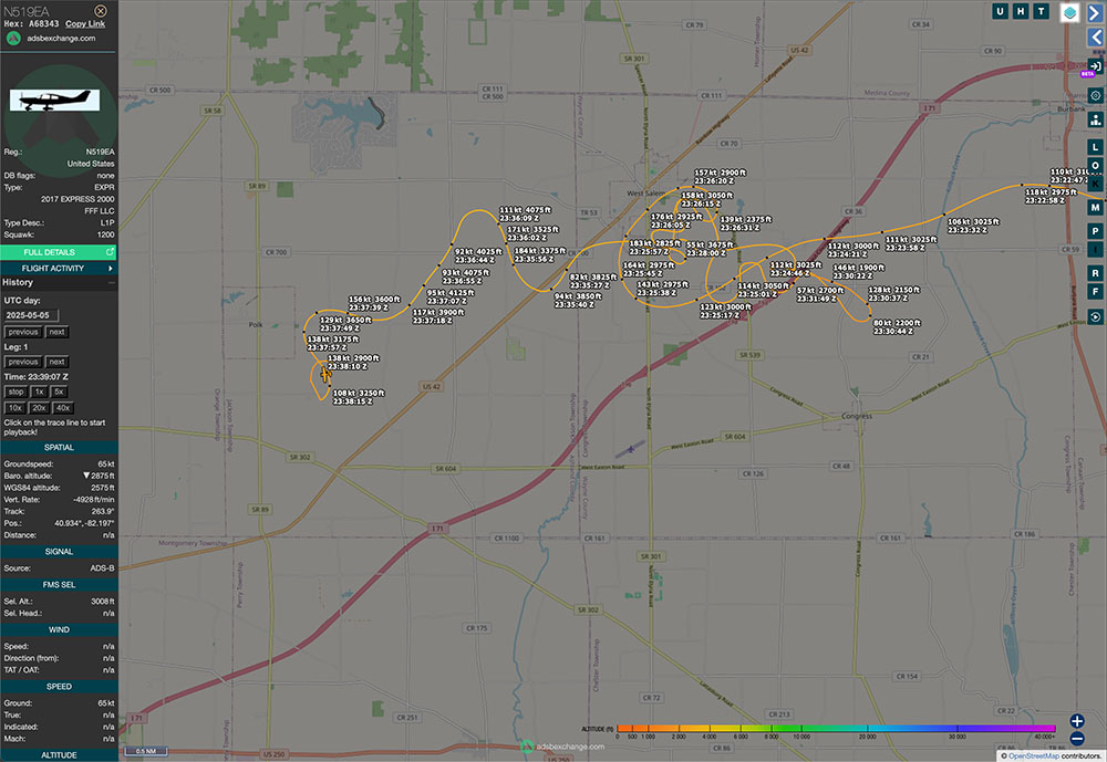
The Express 2000 FT is a kit-built aircraft, and the specific model involved in this accident was manufactured in 2017, with Wolfelt listed as both owner and builder. ADS-B tracking data indicates that the aircraft reached a cruising altitude of approximately 3,000 feet before it began exhibiting an erratic flight path. The duration of the flight was approximately 13 minutes before the aircraft impacted terrain. There were no indications of mid-air breakup or collision with another object. The aircraft was completely destroyed by the impact. The accident occurred during the en route phase of flight.
Meteorological reports at the time of the crash show the area was experiencing adverse weather conditions. Stations near the flight path, including KMFD (Mansfield) and KBJJ (Wayne County), were reporting heavy rain, reduced visibility to 1¼–2 miles, mist, and thunderstorms with cloud ceilings as low as 800 feet above ground level. Lightning was observed in the vicinity, and significant wind gusts were recorded. The aircraft's loss of stable control, as seen in the erratic track data, coincided with the presence of severe convective weather, suggesting a likely correlation between atmospheric instability and the pilot's loss of control or spatial disorientation.
At the time of this report, the National Transportation Safety Board (NTSB) and the FAA have launched a joint investigation to determine the definitive cause of the accident. Preliminary information supports weather as a significant contributing factor, but further analysis of engine condition, instrumentation, pilot records, and maintenance logs will be necessary to determine if any mechanical, structural, or human performance issues contributed to the accident. No other injuries or damage to property on the ground were reported, and the investigation remains active.
This page will be updated as more information becomes available.
Tracking and Social Media
- Flight Tracking: Flightradar24, FlightAware, ADS-B Exchange, AirNav Radar
- Social Media: Facebook, Instagram, X (formerly Twitter)
Sources and References
Please help us by donating


